CENTRAL OREGON HISTORY: The mystery mounds of Shaniko cause travel problems
Published 5:00 am Friday, July 25, 2025
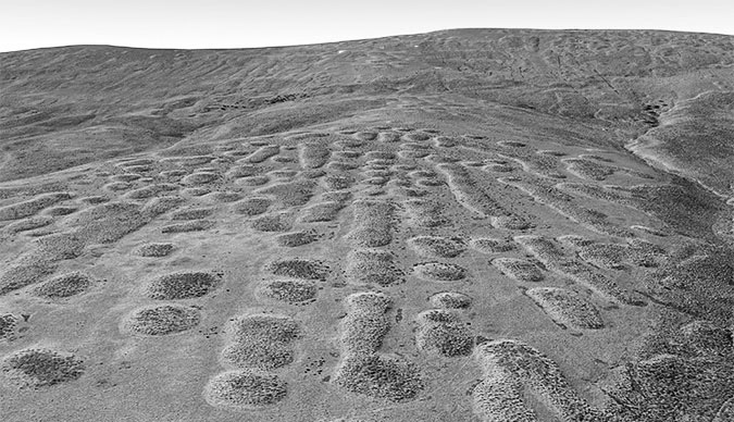
- Desert mystery mounds are photographed at Tygh Ridge. (Submitted by Bowman Museum)
Have you driven on Highway 97 north from Madras to Shaniko and noticed numerous round mounds on the landscape? Have you wondered how they were formed? There are many such mounds east of Mount Hood on the Columbia Plateau. The mounds were called “Biscuit Scablands” by pioneer travelers. The mounds created obstacles for early wagon travel, as they had to maneuver around the rocky fringes of the mounds that were widely located at various intervals.
The pioneer name refers to “biscuits” of mounded soil on the scoured, rocky basalt substrate, or “scabland” that typically surrounds the mounds. These mysterious humps in the desert are usually round, but depending on slight variations in slope, they also appear in oval and oblong shapes.
There have been many theories on the formation of these mounds. Some of the earliest theories were that the mounds were Indian burial grounds, gopher mounds, giant ant hills and wind dunes. Later, there was even a theory that they were formed by extraterrestrials. However, none of these theories have proven to be supportable.
Trending
Field research done in the 1970s by two different Oregon researchers came to the same conclusions on the likely cause of the mounds. Both found that desert mounds are geomorphic relics from the last ice age and were created by soil heave and sorting from repeated freezing and thawing. Clark Nelson, an Oregon State graduate student, wrote a thesis in 1977 that focused on the mounds.
He dissected a desert mound near Shaniko. His field work showed the soil mounds and their stone rings to be interrelated features, formed by the same freeze-thaw cycles during the past ice age, more than 11,000 years ago, when the Columbia Plateau was much colder and much wetter than today. Because these ice age conditions have long passed, Clark also found that the mounds themselves are no longer evolving and instead are simply geologic relics frozen in time.
Nelson found expanses of solid bedrock to be an essential foundation for the soil mounds and rock rings. Wind played a major role in redistributing glacial silt southward from receding ice during the last ice age. The silt began piling in layers on top of the ancient Columbia flood basalts to depths of several feet. When Nelson dissected his desert mound near Shaniko, he found both the wind-blown glacial silts and volcanic ash interspersed in the soil layers that make up the mounds. He believed the desert mounds and their rock rings formed through a process of natural sorting, where fine soil material is pushed up into mounds and rocks pushed out to the edges to form rings through countless cycles of freezing and thawing.
There is a guide map that is available on the internet that has a loop travel route in which many areas of the mounds can be seen.
Steve Lent is a Crook County historian. He can be reached at 541-447-3715.
Trending


-
eEdition
-

-
